
WASHINGTON — NOAA Ship Rainier is continuing it’s Pacific exploration in a mission called RICHARD, which stands for Rainier Integrates Charting Hydrography and Reef Demographics, a collaboration between NOAA’s Office of Coast Survey, Coral Reef Conservation Program, Ocean Acidification Program, and NOAA Fisheries.
The Pacific is the largest and deepest ocean basin on Earth. Many of the islands in its waters – including Guam and American Samoa – sit within or near the Ring of Fire, an area of the Pacific known for earthquakes, tsunamis, and volcanoes. In fact, some Pacific islands and atolls were formed by volcanoes.
Seamounts, extinct volcanoes that rise sharply from the seafloor but remain below the water’s surface, are more common in the Pacific than elsewhere in the ocean. Uncharted seamounts pose a hazard to ships and submarines. Scientists describe seamounts as “oases of life” because so many species live on them.
The Pacific islands, reefs, and atolls are rich in coral biodiversity: there are twice as many coral species there than in the Atlantic. Most corals live in semitropical and tropical waters between the latitudes of 30° north and 30° south of the equator. The shallow reef-building corals are restricted in where they can live by temperature, salinity, and light levels; they need their environments to be warm, salty, and light-filled.
So why did the RICHARD missions go specifically to Guam, the Commonwealth of the Northern Mariana Islands, and even more remote locations like Taʻū Island in American Samoa and Palmyra Atoll in the Northern Line Islands? What all these places have in common is that they are within the U.S.’s exclusive economic zone (EEZ), areas of the ocean where the U.S.has jurisdiction over marine resources.
In the EEZ, the government works to manage things like fish stocks, minerals, and ecologically important habitats, including reefs and marine sanctuaries. To do any of this work effectively and to keep navigation safe, it is necessary to survey the seafloor in the EEZs.
The RICHARD hydrographers’ first objective was to collect high-resolution bathymetric data that would tell them how deep the water was and also discover formations on the seafloor. Such basic data previously did not exist for some of the islands the hydrographers surveyed, and some of the seafloor information they did have was more than 80 years old.
The Office of Coast Survey will use the hydrographic data collected on the RICHARD missions to update and improve nautical charts for the region. Captains of cruise ships, tankers, and sailboats and other mariners using the charts will be able to navigate around the islands without hitting reefs, seamounts, wreckage from World War II, and other hazards, thereby protecting their vessels and marine habitats.
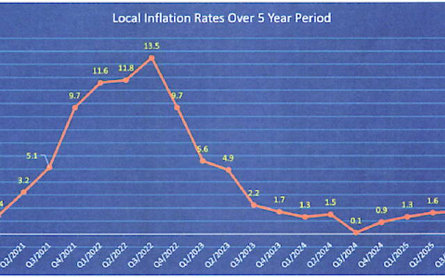 is -1.3% this quarter. Among the thirty food items that have seen a price drop, one item significantly contributed to this decline, eggs.")
Comments
Sorted by BestComments are powered by Disqus. By commenting, you agree to their privacy policy.
Powered by Disqus