Pago Pago, AMERICAN SAMOA — Two to four Tropical Cyclones (TC) predicted to be heading to American Samoa are not actually Tropical Cyclones.
The National Weather Service Pago Pago has released its weekly forecast for this week, with an “overview of the latest satellite images showing a very unstable atmospheric environment.”
Neighboring Samoa is also predicting two to three TCs , and would they be affecting American Samoa as well?
Meteorologist Jane Allen in an interview with Samoa News yesterday, said, “We’ve usually encouraged our people here in the Territory, to follow up with the local forecast. While those who reside in Western Samoa follow up on their forecast.
However she said, the local outlook of last week’s risk has been elevated.
“Our TC is within 300 nautical miles of our area, right now there aren’t any, because those can occur in a matter of days, so it’s not that it’s happening now, but the risk of it forming is a lot higher.” she said.
“But we don’t see any in the meantime.”
“Just look out for our forecasts and make sure you follow us.”
This week’s forecast stated, “an Hourly observations throughout the day together with the increased perceptible water (PWAT) content in the atmosphere hints at higher cloud coverage and precipitation probability.”
These conditions are forecast to remain over the islands throughout the week as the trough to the North migrate South bringing flash flooding conditions, peaking on Tuesday night through Wednesday night.
Therefore, expect numerous to widespread showers with embedded thunderstorms and fresh (20 mph) easterlies for the first half of the week.
Showers will decrease to scattered to numerous with moderate (15 mph) north easterlies for the second half of the week.
Additionally, expect flash flood conditions to be the main threat for this week, with the likelihood of a flash flood watch for the peaked time frame.
Marine: Model data shows a downward trend of combined seas and winds for this week. This coincides with the decrease in winds throughout the week from fresh breeze (20 knots) to moderate easterlies (15 knots). Combined seas of 9 to 12 feet will gradually subside to 7 to 9 feet on Tuesday, and further subside to below advisory thresholds on Wednesday into the rest of the week. Therefore, the advisories for high surfs and small crafts remain in effect through at least Tuesday night. Nevertheless, with the trough to the north migrating over the territory by Tuesday night, this may increase the probability of thunderstorms.
Thunderstorms have the ability to produce higher seas and gusty winds nearby.
CURRENT Watches, Warnings, Advisories:
• High Surf Advisory
• Small Craft Advisory
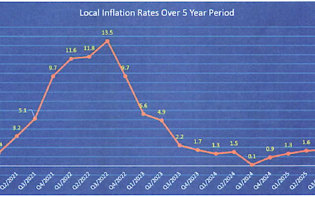 is -1.3% this quarter. Among the thirty food items that have seen a price drop, one item significantly contributed to this decline, eggs.")
Comments
Sorted by BestComments are powered by Disqus. By commenting, you agree to their privacy policy.
Powered by Disqus