
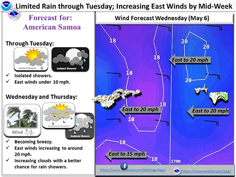
Pago Pago, AMERICA SAMOA — Rain will be limited across the American Samoan island chain to begin the work week. However winds, clouds and chances for rain will all begin to increase over the islands Wednesday through Thursday.
The latest model suggests a dominant high pressure to the south, keeping partly cloudy conditions with isolated showers over the region. This high pressure will help keep the trough south of the area. A low pressure embedded within the trough line will continue to migrate southeastward as it builds by midweek.
Another high pressure to the southwest will follow as the ridge to the north continues to build. The latest satellite imagery show very minimal cloud coverage in the area. Clearly on satellite imagery, there`s very little moisture content in the area, keeping dry air masses in the vicinity. However, with very strong high pressures to the south migrating eastward, passing showers together with tradewinds will remain across the territory for the long term forecast.
American Samoa can expect isolated to scattered showers for the short term forecast and through the rest of the forecast period. Winds are easterly on Tuesday through Friday peaking to fresh breeze on Wednesday night, and drop to variable winds thereafter.
There are no watches, warnings, or advisories at this time.
Local News
Limited rain through Tuesday; Increasing east winds by mid-week
Comments
Sorted by BestComments are powered by Disqus. By commenting, you agree to their privacy policy.
Powered by Disqus