Pago Pago, AMERICAN SAMOA — The U.S. National Weather Service Pago Pago is closely monitoring a tropical system within its area of responsibility (AOR). Tropical Disturbance 03F (TD03F-96P) is approximately 281 nm south-southwest of Pago Pago.
A tropical disturbance is the beginning stage of a tropical cyclone with 15 to 25 mph (15-20 knots) winds near the center. TD03F is expected to move southeast as it intensifies into a subtropical system within the next 24 to 48 hours. Currently, TD03F has no threat to American Samoa.
However, as TD03F migrates southeast, the South Pacific Convergence Zone (SPCZ) will likely remain over the area throughout the week. The SPCZ will continue to produce gusty north-northwest winds and heavy downpours within the AOR. A large swell together with the strong north-northwest winds will continue to elevate seas and enhance surfs over coastal waters, especially the north facing shores of all islands.
The following alerts in effect.
• High Surf Warning is in effect for the north facing shores
• High Surf Advisory is in effect for the south and east facing shores
• Wind Advisory is in effect for all islands
• Small Craft Advisory is in effect for coastal waters of American Samoa
• Flood Watch remains in effect through at least Friday
Please heed all warnings, advisories, and watches for your safety. A reminder that American Samoa is still in the Hurricane Season, please stay prepared.
For more information on preparedness please reach out to American Samoa Department of Homeland Security at 699-3800.
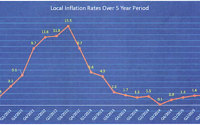 is -1.3% this quarter. Among the thirty food items that have seen a price drop, one item significantly contributed to this decline, eggs.")
Comments
Sorted by BestComments are powered by Disqus. By commenting, you agree to their privacy policy.
Powered by Disqus